Follow Kyle's and my 13 day journey on the Annapurna Circuit in the Himalayas of Nepal. There were so many good photos to choose from but I managed to narrow it down to a couple dozen. This is a long one. Buckle up.
 |
| Swayambhun stupa in Kathmandu |
Kyle and I arrived in Kathmandu on our anniversary! We spent 3 nights in the capital at Aryatara, a great hotel in Thamel, the tourist district. Thamel is where trekkers and climbers come before and after their trip to find guides, buy gear and eat at the many international restaurants after getting sick of daal bhat on the trail. We spent our time seeing some of the sights of Kathmandu, stocking up on trekking necessities such as kitkat bars and spare pens, and organized our permits at the Tourism Board. We required at TIMS card and and an Annapurna Conservation Area Project (ACAP) card for our trip, which were both checked sporadically during the trek. The Annapurna Circuit does not require a trekking permit, but some of the side treks do so check before you go. All the permits can be arranged in Kathmandu beforehand and for half the price of purchasing on the trek.
 |
| All my gear for the 2 week trek |
The main trekking season is in September/October, after the rainy season. Since we didn't have much flexibility, we arrived right at the start of the monsoon. We were fortunate that it didn't affect our trip too much, and we lucked out with good weather during the trek. One thing we encountered with trekking during low season was that there were very few other trekkers. We went for two days before seeing any other trekkers at the start. Also, some of the tea houses were closed for the season or would be out of some ingredients. It wasn't a big deal and we never had any issues finding somewhere to sleep or eat. The government has been building roads to connect some of the main towns in the Annapurna region, often destroying trekking trail to replace it with road. The ACAP group has been working to make new trekking trails that avoid the road, but we did encounter times when the road was the only option. It was hot and dusty so people will shorten the trek on either end by skipping road sections in a jeep.
 |
| Permits purchased and ready to trek |
Itinerary (13 days)
1. Kathmandu to Ngadi
2. Ngadi to Chamje
3. Chamje to Temang
4. Temang to Upper Pisang
5. Upper Pisang to Braka
6. Braka to Manang (Ice Lake Side Trek)
7. Manang to Tilicho Lake Base Camp (Tilicho Lake Side Trek)
8. Tilicho Lake Base Camp to Shree Kaharka (Tilicho Lake Side Trek)
9. Shree Kaharka to Thorung Phedi
10. Thorung Phedi to Muktinath
11. Muktinath to Jomsom
12. Jomsom to Tatopani (by local bus)
13. Tatopani to Pokhara (by local bus)
Our must have items (beyond your standard hiking gear)
It is really hard to pack for a 2 week hiking trip where your temperature range is 0 to 35 degrees. We went pretty basic on our clothes and tried to keep our packs as light as possible, however there were a few "luxury items" that we were very happy to have along:
water purification: you can buy bottled water all along the trek, however as you get climb into the mountains, so does the price. There are cheap "safe drinking water stations" in some towns, but are not as frequent as you would like. Every town has water taps and there are many streams to fill your bottle. You can pick up tablets along the trail but we brought pristine from home
pack towel: almost every tea house advertises a hot shower. Towel not provided
soap + shampoo: again, not provided with the shower
hand sanitizer: after spinning all the prayer wheels its nice to clean the hands prior to eating
toilet paper: once you leave Kathmandu or Pokhara, you won't be seeing any more western toilets. Squat toilets are are your only choice and unless you feel confident with a bucket of water, it was very nice to have toilet paper with us. You can also buy it along the trail for a premium
sleeping bag: as you make your way up the trek, the nights get colds and the blankets get thicker. You could probably get by without a sleeping bag but I really appreciated having that extra warmth on the cold nights
headlamp: this came in more useful in Kathmandu and Pokhara where they have issues with power shedding, but we also had a few times when the headlamp was necessary along the trek
book: despite the long days on the trail, we were typically done walking by 3-4pm. Dinner can take upwards of an hour to prepare so it was nice to veg out and read. I had an e-reader and knocked off a couple books without using up extra space. Some tea houses will have book exchanges in with a variety of books in various languages
charger: we bought a local USB charger in Kathmandu and used it to charge all our devices. It was smaller and lighter than a multi converter and worked really well. Most places had a place to charge devices and WiFi!
flip-flops/camp shoes: after a long day in hiking boots/shoes, it was such a treat to change footwear. Kyle brought warm woolly socks to wear with his flip flops (very fashionable) on cold evenings
chocolate bars: Although you can buy all your food along the trail, having chocolate bars in your pack was a nice treat. Chocolate was definitely a currency for trekkers and you could buy bars everywhere (cheapest in Kathmandu and Manang). Try the "mars roll" or "snickers roll" offered at many tea houses (deep fried candy bars)
Guidebook + Map: we bought an Annapurna Circuit guidebook in Kathmandu for 995R ($9.95). It wasn't always completely accurate but it was nice to have some suggestions and tips for the trail and some information about the area as we did not travel with a guide. It also provided some entertainment as the authors are definitely ESL. The map we got was the updated map with the new trekking trails (Around Annapurna NA503). It was fairly accurate and helped us with planning our days, although we were often quite a bit quicker than the provided walking times
cash: there are no ATM's on the trail. We were spending between 3500-5500R per day for 2 people. This included the occasional beer, apple pie and raksi (local millet wine)
Things we didn't need
umbrella: everyone tells you that you will need it. You don't
Day 1 - Kathmandu to Besi Sahar to Ngadi - 6 hrs by car + 13 km walking
Our hotel organized a driver for us the Besi Sahar, the starting point for the Annapurna Circuit. The 170 km drive took 6 hours. We walked from Besi Sahar to Ngadi and stayed the night in our first "teahouse." It was very basic with a small bed and a bug net, and an attached bathroom with a squat toilet. It was hot and humid during the day as we were in the jungle, but it cooled off significantly at night. We could hear the roar of the Marsyangdi river behind our room all night. We had our first of many meals of daal bhat (lentils + rice) and got an early night.
 |
| Traffic on the Prithvi Highway (the main highway between Kathmandu and India) |
 |
| Downtown Besi Sahar - the start of the Annapurna Circuit |
 |
| A lonely road up to start the trek. No other trekkers to be found and not much activity on this side of the valley as the main road is on the other side |
 |
| Chinese companies have been damming rivers and building hydro dams in the Annapurna region. The trek took us through this spooky tunnel on day 1 and was the nicest road we saw the entire time we were in Nepal. |
 |
| Kids walking home from school greeted us with "Namaste" then demanded photos and sweets. We had a camera but weren't quite ready to part with any of our chocolate bars |
 |
| Finishing up my daal bhat as the tea house owner's daughter shows me her printing |
Day 2 - Ngadi to Chamje (Rainbow Falls) +1400 m elevation / 23 km
Our second day was one of our hardest. We were full of energy after a breakfast of Tibetan bread, omlettes and masala chai. We were trying to follow a 14 day itinerary for the 200km loop, but were already behind as many people choose to take a jeep past the initial few towns. It was hot and humid. We had blisters and chaffing to deal with as well as lots of elevation gain and loss as we followed trails marked with white and red paint up and down the hill sides. The trail follows a large, steep valley and nothing is flat. By the time we had reached Rainbow Falls, we were exhausted. The plan had been to carry on for another 2 hours to the town of Tal, which would get us back on our itinerary, but there was no way we could have done it. As if to solidify that fact, it started to pour rain as we checked into one of the most beautiful tea houses on the entire trek. It was meant to be and well worth the steep detour we took to reach it.
 |
| Kyle on the trail through small villages |
 |
| Terraces of crops and green jungle found in the lowlands |
|
|
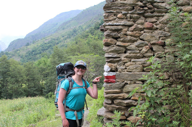
Trail markings were sometimes obvious and other times non-existant. Having an updated map with the new trails was very helpful
|
|
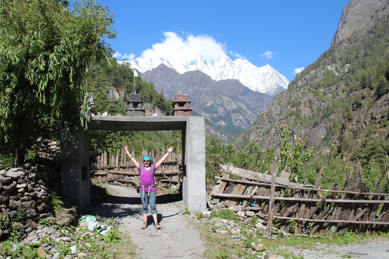
Archways mark the trek at many along the way
|
|
|
Jeeps on the road heading back to Besi Sahar. The road is wide enough for one vehicle and very rough. It sounded like a
terrifying ride
|
|
|
The high road or the low road, that is the question. The reward was the stunning Rainbow Falls tea house
|
|
|
Journaling beside the rainbow falls. Tea houses were frequent along the trail and very reasonably priced. You could often negotiate for a free room if you agreed to buy dinner and breakfast there. You could place your order for the morning so breakfast was ready when you got up, which helped with the early morning starts that became routine
|
|
Day 3 - Chamje to Temang +1550 m / 25 km
Day 3 was another big one. We had started getting up early to beat the heat and that became the standard for the rest of the trek. We started with a big climb up to Tal and finished with a long climb up to the town of Temang. By this point we were still deep in the river valley and hadn't seen the Annapurnas yet, but huge mountains rose straight up above us on all sides, and from Temang, Manaslu could be spotted to the east. We had finally met up with some other trekkers and started leap-frogging with them during the day. It was nice to see other people on the trek and chat with them. We met trekkers from Mongolia, Nepal, USA, Germany, Canada, Netherlands, Finland and the UK along our trek.
 |
| Porter carrying branches between villages |
 |
| Weeds growing at the side of the road |
 |
| Spinning prayer wheels at one of the many mani walls along the trek. You must walk around the walls or stupas clockwise and spin the prayer wheels clockwise also |
 |
| Mule caravan making its way out of Tal |
 |
| Evidence of rockfall onto the road. We also saw many people were working with sledgehammers and hammers to break rocks to build new sections of road. It looked like hard physical work |
 |
| Small shops selling Coke, Fanta, cookies, chocolates and raman noodles dotted the trail |
 |
| We left the jungle behind and entered into pine forests as we approached Temang |
Day 4 - Temang - Upper Pisang +1190 m / 24.7 km
After 2 hard days, we planned on taking a rest day. We were on track for a 14 day trek and feeling pretty good. We arrived at our planned destination of Chame at 9 am. The book we had with us told us it was 7 hrs walking to the next major town so we had planned on saving it for the following day. After a failed attempt at going to some hot springs and a mid-morning snack of fried noodles, we decided to push on. This meant for another long day, but we stopped often for Fanta or Coke and made good time to the next town. This was our first day where we had views of Annapurna II. We also walked through an amazing area, past a huge rock formation called the Gateway to Heaven. The scale in these mountains is incredible. Upper Pisang ended up being one of our favourite towns and we were finally out of the sweltering heat of the lowlands. The vegetation changed from tropical to pine forests and I wore my jacket and toque for the first time of the trip. We had been planning on no showers for the 2 week trek so it was surprising to discover that not only did most places have hot showers, they all seemed to have free WiFi as well! How luxurious. In Upper Pisang, we were the only ones at our tea house. While exploring the town before dinner, we happened upon a few other trekkers who were up at the gompa on the hill. They invited us to play cards at their tea house and we became fast friends.
 |
| Sometimes the signs for the trekking trail were pretty obvious |
 |
| Our first view of Annapurna II (7937 m) |
 |
| Cheapest and best fried noodles of the trip were cooked right in front of us |
 |
| Leaving Chame |
 |
| Amazing views and suspension bridges |
 |
| View of Annapurna II from the Upper Pisang gompa |
 |
| Ornate decoration inside the gompa |
 |
| Mandala on the ceiling in the Buddhist gompa |
 |
| Daal bhat dinner in Upper Pisang |
Day 5 - Upper Pisang - Braka +888 m / 22.5 km
At this point we had climbed from 760 m to 3320 m (with lots of up and down in between). We started taking Diamox for altitude at this point and needed to be aware of how much elevation we were gaining per day. In order to avoid altitude illness, it is important to avoid ascending too quickly and the recommendation is to only sleep 700 m above the previous night. There were two options for the walk from Pisang to Braka (15 mins walk from the larger town of Manang). The first was the low route along the road, and the second was along the trekking trail, climbing up to 3700 m then descending to Braka (3450m). We chose the upper trail because of the views from the high road, as well as the ability to start doing some acclimatization by spending the day higher than we were sleeping. We were not disappointed. The vistas were unreal and we got to see Annapurna III, Chulu and other huge peaks. The day started with a very steep climb up switchbacks, then contoured the hillside for most of the day. This was one of the best days for views and we had great weather!
This was our first time during the trek that we experienced effects of the altitude. We both had headaches and were feeling pretty tired. I had a cough that refused to go away and Kyle was still struggling with jet lag as we had only arrived one week before. Food and water was getting more expensive as we got farther from Besi Sahar. We had stopped buying bottled water and switched to using pristine to purify water from the taps in towns as the price of 1L had gone from 50 R (50 cents) to 250 R ($2.50 US) in the last few days. When you are drinking 3-4 litres per day each, it became a significant expense considering a meal was $5-6. There are some towns with safe drinking water stations where you could fill your bottle for about 40-60 R, however they were few and far between during this part of the trek. We passed through the beautiful town of Ngawal and the deserted town of Julu before dropping down to the road and Braka. We passed a huge monastary and a Tibetan boarding school. As we approached Braka, we caught up with the trekkers we had played cards with the night before. They were carrying onto Manang for a rest day but we stopped in Braka as our book recommended the bakery in town and we wanted to do a side trek to Ice Lake that started from the town for acclimatization the next day.
 |
| Safe drinking water station in Chame |
 |
| Huge prayer wheel we found in an unassuming building at the side of the road |
 |
| Mani wall and prayer flags of Upper Pisang as we look back towards Annapurna II |
 |
| Looking back to the town of Ghyaru at the top of the switchbacks, perched on the hillside. Upper Pisang out of sight to the right. That climb was terrible and the air seemed thin at 3700 m |
 |
| The gateway to heaven with Upper and Lower Pisang below |
 |
| The town of Ngawal. We were told we would have to climb that large hill (Kyle was not very happy about that). Fortunately, the trail took more of a traversing route and we got to skip the climb |
 |
| Big mountains above |
 |
| Annapurna views from the high road from Upper Pisang to Julu. Some of the most stunning views of the trek |
 |
| New views around every corner |
 |
| Making friends with the local cows in Julu. I think more cows live there than people |
 |
| Goats being herded between villages |
 |
| Enjoying a hot mug of chai as the sun sets in Braka |
Day 6 - Ice Lake Side-Trek +1100 m / 13 km
Unfortunately, the bakery in Braka had closed for the season a few days prior. No apple pie for us! I was feeling pretty sick when I went to bed, but fortunately woke up feeling quite a bit better. Both of us had recovered from our headaches of the previous day. It is recommended to spend 2 nights at ~3500 m before continuing to ascend and many people will take a rest day. Since we were feeling good, we decided to head up to Ice Lake, a small lake at 4600 m, to help with acclimatization and to get some good views. The trail was steep and steady up to the lake. We passed yak herders camped at ~4200 m and saw an old lady taking cows up the trail. The altitude didn't seem to be affecting them. We were able to leave most of our trekking gear at the tea house and it was nice to have a lighter pack for a change. We had opted to do the trek without porters or guides, which gave us the freedom to take as long as we wanted rather than sticking to a strict itinerary. The lake was nice, but the mountains above were the main attraction. The side trek was well worth the effort and our best views of the entire trip.
 |
| Starting up the trail to Ice Lake through the old part of Braka |
 |
| Kyle at Ice Lake (4600 m) |
 |
| Cannot stop looking at the Himalayas. Insane views from Ice Lake |
 |
| Looking back down the mountain to Manang and up the valley towards Tilicho Lake |
 |
| Stunning landscape |
 |
| Clouds rolling in for the afternoon after a bluebird morning |
 |
| We finished the day with a 15 minute walk along the road to the town of Manang where we joined up with Aleksi, Gijs, Steen and Catalina |
Day 7 - Manang - Base Camp (Tilicho Lake Side Trek) +930 m / 16 km
Manang is where many trekkers take a rest day and the town is set up for it. There was an amazing bakery and multiple projector halls where you could watch classing mountain movies. We met up with our friends and stayed with them at a tea house in Manang. Up until this point, Kyle and I had always been getting daal bhat for dinner thinking it was the fastest and cheapest option. All the food is made from scratch by one or two guys in the kitchen after you order it so usually takes about 1 - 1.5 hours to get the food. During the high season, the porters and guides help in the kitchen in exchange for dinner and a place to sleep. This speeds things up for the increased number of trekkers and the tea houses don't have to pay more staff. The Nepali all eat daal bhat, often for 2 or 3 meals per day. So, during high season, there is always lots of daal bhat (which is always an "all you can eat item" and its usually ready to go. For us we discovered, it took a long time to prepare and they only would make enough for us to have 2 helpings each, which was plenty. It was good fuel for the trail and alot of food for your money, but it got old pretty quickly. We began to try new things, like noodle soups and chicken sizzler dishes. In most places they served pasta, pizza, steak but we didn't really go for that. Lots of the soups were made from packets with hot water, but the Tibetan Thukpa soup was often handmade and had local veggies. Yum!
From Manang, Kyle and I had decided to do a side trek to Tilicho Lake, the highest lake in the world at 4919 m (not including smaller glacial tarns). It was going to add 2-3 days onto our trek, but we figured that since we were there we may as well go for it. We convinced Gijs, Aleksi and Steen to join us. Catalina couldn't be convinced so we parted ways with her as she ventured off for Thorung-La pass solo. We hiked up to the Base Camp below Tilicho Lake. There, we found many other trekkers that we had been passing back and forth in the last few days. Alphina and Serge, our favourite Russians, were easy to spot in their matching bright red Patagonia expedition jackets and Elizabeth and Steve from the UK arrived after us. The trail crossed huge scree slopes and wound through giant hoodoos. We had left the treeline and were up in the alpine. The temperature was dropping and we got some rain at base camp. We arrived around noon so we ordered a "large pot" of hot chocolate to share and cuddled up to stretch, read and nap. This was our most restful day yet.
 |
| First baked goods of the trip. So nice after a few days on the trail |
 |
| Who wants to go see a movie? |
 |
| Getting permits stamped before heading off to Tilicho Lake |
 |
| Local kids found Steens camera and wanted to test it out |
 |
| Leaving the red and white markings for the blue and white of the side trek |
 |
| Crossing large suspension bridges became routine |
 |
| Crossing scree slopes on the way to Tilicho Lake Base Camp |
 |
| Some parts of the trail were pretty exposed! |
 |
| A large pot in Nepal is enough for 10 mugs of hot chocolate! |
 |
| Getting cozy on the couch with our "small pot" of masala tea (Nepali Tea) |
Day 8 - Basecamp - Tilicho Lake (4919 m) - Lower Shree Khaharka (Tilicho Lake Side Trek)
+800 m / 20 km
Up early again, we set off for Tilicho Lake with nice light packs. It was a constant climb, with a section of switchbacks that was quite steep. It was a grey day, but every so often the mountain tops around us would peak out of the clouds. I was really noticing the altitude at this point and had to take it pretty slow. When we arrived at the lake, I was surprised how big it was. Unfortunately, the tea house on the ridge above was closed for the season, but we sheltered from the wind behind it and celebrated with Mars Bars (the trekkers currency). We hung out for about an hour and despite being close to 5000m, were actually feeling pretty good. The side trek was really helpful for acclimatizing for our upcoming push over Thorong-La Pass (5416m) two days later. After enjoying the view of Tilicho Lake, we walked back to Base Camp (4150 m), repacked our bags, and set off to Shree Kaharka (3900), a small town not too far from Manang. We had done some good planning on the acclimatization and were feeling ready for the pass ahead.
 |
| Heading up towards Tilicho Lake and into the clouds |
 |
| Sheltering from the wind at the Tilicho Lake Tea House with the boys |
 |
| My honeymoon buddy! |
 |
| Tilicho Lake with the whole crew |
 |
| Hiking back down from Base Camp |
 |
| Cool hoodoos and scree slopes |
 |
| Kyle and Steen hiking along the hoodoo trail |
Day 9 - Shree Kaharka - Thorung Phedi (Thorung-La Base Camp) +980 m / 18 km
We went to bed with rain falling and awoke in a cloud at Shree Kaharka. As we ate breakfast, the clouds started to burn off and we were greeted with a brilliant sunny day. The hike to Thorung Phedi (4540m) wasn't too steep, but we spent the day hiking above 4000 m so every uphill incline felt pretty challenging. Amazingly, downhill and flat pretty much feels the same when you are at altitude but as soon as you start to climb, it takes your breath away. When we arrived at the Thorung-La Base Camp, we were tired. Kyle was coming down with something so we drank hot lemon, had hot soup and went to bed super early with a plan to start early for the pass the next morning.
 |
| Old Khangsar ruin in the sunshine |
 |
| Looking back down the valley to Manang |
 |
| Transferring valleys on the way to Thorung Phedi |
 |
| Huge mountains rise 3000m above us! |
 |
| Mandatory selfie |
 |
| Very fluffy high altitude cows |
 |
| Yak cheese for sale |
 |
| More suspension bridges |
 |
| Made it to Thorong Base Camp! (4540m) |
 |
| Base Camp chill out time |
Day 10 - Thorong Phedi - Muktinath (over Thorung-La Pass) - +984 m/-1800m + 12 km
We woke up at 5 am for breakfast. You couldn't see a thing and it was raining lightly. Not ideal for travel through the pass. After much deliberation, we decided that we would not be going for the pass that day as trekkers have become disoriented and lost, developed hypothermia or altitude sickness in Thorung La Pass and there have been numerous rescues. We also wanted to get some views from the top of our trek. I went back to bed, Kyle curled up with a book, and the other guys hung out in the common area. At 8am, Steen knocked on our door. The clouds were starting to part so we made a quick decision to go for it. Kyle was still feeling sick and he wanted to be through the hard part of the trek and back down to 3500 m. Aleksi and Gijs wanted to hold out for clear weather and decided to stay back. We quickly packed our bags and said our goodbyes before slowly starting up the steep switchbacks to Thorung High Camp just after 9 (a very late start for the pass).
Clouds were rolling in and out and we would occasionally catch glimpses of the huge peaks above us. The trail was well marked with metal poles, which come in handy in poor visibility or snow, which is a frequent occurrence. We had a few flurries on the way up but nothing was sticking. We reached the top of the pass in 2 hrs 45 mins after a long slow slog. The book describes 15 false summits and I believe it. Every slight rise looks like the top of the pass but it tricks you. We were moving as fast as molasses thanks to the altitude and got passed like we were standing still by 2 Nepali guys in jeans with bottles of coke in their water bottle pockets. When we arrived at Thorung-La there were a few other trekkers hanging out. One girl had been there for 3 hours and was waiting for the clouds to clear. She told us that if it didn't clear up by 1 pm she would head back to High Camp and try again the next day. We looked at her like she was totally nuts and decided she probably had altitude sickness. The girl that was trekking with her felt the same way and decided to head down with us, leaving the crazy girl at the pass after she assured us that she wouldn't stay past 1. Fortunately we saw her in town that night, otherwise I would have been very concerned that she just waited there all day.
The walk down from the pass was challenging as you descend 1800m in 6km, but fast. The Muktinath side of the pass was sunny and bright, compared to the dark threatening clouds we had left behind us. When we descended into Muktinath it was like arriving at an oasis. We were a bit delirious from the effort of the day and the number of days on the trail and thankful to have arrived. The air was deliciously thick and prices (which had been constantly climbing as we gained altitude) were much lower, thanks to the road and number of travelers that visit Muktinath. Many Indian visitors pilgrimage to Muktinath to visit the large temple, so the access is significantly easier than the towns on the other side of the pass. Some people finish their trek here as it is easy to hire a jeep. We splurged on cold beer, tried a bottle of chang (Nepali beer which sort of tastes like sour yogurt beer - better than it sounds) and gorged ourselves on our first yak burgers which set the bar we for all future yak burgers. Yum!
 |
| Although the Nepali all seemed to speak some English, the translations on the signs could be confusing |
 |
| We didn't see any snow leopards, but we did spot a few "blue sheep" - a type of deer found at high altitude |
 |
| The deserted looking Thorong High Camp |
 |
| Scree moraines climb seemingly endlessly to Thorong-La Pass |
 |
| Prayer flags mark the way past high camp |
 |
| At 5000 m every step is slow and breathing is tough |
 |
| We made it! |
 |
| Now time for the 1800m of descent into Muktinath |
 |
| Arriving in Muktinath (3500 m) was like arriving in an oasis after spending the last 5 days in the alpine |
|
|
Muktinath Temple is a pilgrimage site for both Hindus and Buddhists, who often travel by plane, jeep then donkey to reach the temple and its natural hot springs
|
Day 11 - Muktinath to Jomsom -1070m + 24 km
After arriving in Muktinath, Kyle and I set out to find ourselves mountain bikes to rent for the last few days of the trek. There was an article in Outside Magazine that raved about it and we had seen a sign at the Tilicho Lake Base Camp advertising rentals in Muktinath. We were very excited to have a day or two off the feet and to cruise down to Tatopani in a day or two (3-4 days of trekking). However, there were no rental bikes to be found. Even when we asked around people didn't know what we were talking about. The internet gave us some vague leads but the website Kyle had visited before our departure was a broken link and we could only find anecdotal information. Thwarted.
Although we were disappointed in our inability to rent bikes, Steen was excited that we would be continuing the trek with him, at least until Jomsom where we knew bikes would be available. There are two options for walking to Jomsom,; one more direct route through Lupra Pass, or through the town of Kagbeni. We were not interested in any more passes thank you very much and had heard that Kagbeni had a restaurant called Yak Donalds. We had to check it out.
As we left Muktinath, I got us off route and we started heading towards the heavily regulated Upper Mustang before realizing our mistake and turning back quickly. You need some serious permits for this area, but I would love to go back and explore it on mountain bikes. Next time. We got back on track and started the long descent through desert towards Kagbeni. We had read a bit about the wind on this section of the trek but hadn't thought much of it, until it started trying to blow our hats off. By the time we got to Kagbeni, it was so windy we could barely talk to each other and had to shout to be heard. We wandered Kagbeni until we found Yak Donalds and each got a "Happy Meal" - Yak Cheese Burger, Fries, and a pop. It wasn't as good as our Yak Burger the night before, but still delicious. Steen had been on the hunt for chocolate cake since Manang where he missed out on a slice at the bakery by a few minutes. Unfortunately, everywhere we went had it on the menu, but they were always sold out. Poor Steen.
The second half of the day was walking through the wide Kali Gondaki Gorge to Jomsom. There is no trekking trail to follow so we walked on dusty roads all the way. We were offered a ride in a jeep for the low price of 100 R per person ($1 each), but we declined. About 2 minutes later we turned a corner and were hit in the face with some of the strongest wind I have ever encountered. We were getting sand blasted by the dust and had to cover our faces with our buffs to keep from inhaling all the dust. It was awful and we had about 2 hours of walking to go. We were definitely regretting our decision to turn down the ride. By the time we arrived in Jomsom, we were exhausted from the roar of the wind. Kyle was feeling pretty unwell again with a nasty cough. The first bit of Jomsom is really unwelcoming. We couldn't see anywhere to stay and it seemed really rough. Although we were tired, we kept walking and finally arrived in more of a tourist area on the far side of town near the airport. We even ran into a few groups of trekkers that we had walked with earlier in the trek!
 |
| We
had planned on renting mountain bikes in Muktinath or Jomsom to ride
down the last few days to Tatopani. This sign got our hopes up as we
hadn't reserved anything. Unfortunately it lied. This place no longer
exists and the only way to rent mountain bikes is to have them flown up from Pokhara then transported by Jeep as Andrew and Kalen did. |
 |
| The Muktinath region seemed much different than the Manang region. It was much more like a desert and there were way more tourists traveling around in Jeeps |
 |
| Looking back up to Thorong-La Pass. A much better weather day but oh well. Note the switchbacks of the road that winds up towards the pass |
 |
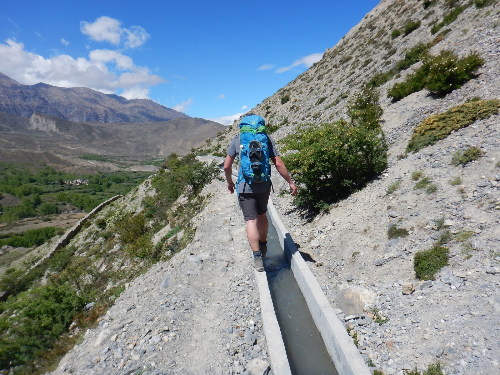
| Getting off the beaten path and taking an aquaduct |
 |
| Spotting an 8000 m peak up ahead - Dhaulagiri |
 |
| Another ecosystem change as we make our way into the Kali Gandaki Gorge, the so-called largest gorge in the world as it has a relief of over 5000 m (from Jomsom at 2700 m to Dhaulagiri on one side and Annapurna I on the other, both over 8000 m) |
 |
| Descending into Kagbeni and excited for Yak Donalds |
 |
| Windy walking into the Kali Gondaki |
 |
| Prayer wheels and stupas in the really picturesque and beautiful town of Kagbeni |
 |
| Nepali boy outside Yak Donalds |
 |
| A Yak Donalds Happy Meal - a bit different than a North American Happy Meal and much tastier |
 |
| Exploring in Kagbeni |
 |
| The road to Jomsom wasn't really that much of a road, Jeep traffic only |
 |
| Are we there yet? Getting sandblasted by the wind in the Kali Gondaki |
Day 12 - Jomsom - Tatopani (by local bus)
The next morning, Kyle was definitely sick. This was where our trek came to an end. We said goodbye to Steen who was going to carry on towards Tatopani on foot. I went looking for mountain bikes and actually found a place (Om's Home) that will rent bikes out but they had no bikes that were rideable. After a trekking season of abuse, they were all broken. It was an easy choice to book a bus to Tatopani, which saved us 2 days of walking. We could have got a private vehicle but that would have cost $150 USD. The bus was much cheaper - $8 per person, but we had to wait a few hours. We grabbed coffee, caught up on our journals and just chilled out. We hadn't really done much of that yet. We also stocked up on some cold meds for Kyle, which are easy to get at any pharmacy for very cheap. The bus ride was an "adventure" of its own. When we got on, there was nowhere to sit so we spent the first 45 bumpy minutes hanging on for dear life to the luggage racks. Kyle was too tall for the bus and was smashing his head into the roof every few seconds. Eventually, other passengers shifted around a bit so Kyle could wedge himself in the middle of an Indian family and I sat on the ground on the spare tire. The ride was slow and terrifying. The road is built into a cliff and drops off vertically a few inches from the tires. It got really exciting when we had to pass large trucks, including a flatbed carrying a massive excavator. As the bus rocked side to side over the huge potholes, I was convinced that this was how I was going to die. The best part was the drivers music choices which included We Will Rock You by Queen, Hello From the Other Side by Adele and an assortment of happy Indian songs. Somehow we survived the 4 hours of torture and arrived in Tatopani very shaken up but happy to be alive.
The next morning, we got back on the bus and spent 7 hours bouncing our way to Pokhara, the main tourist city at the foot of Annapurna I and Mt. Fishtail (Machapuchare). The first few hours were similar to the previous day, but we had got on early enough to have seats. Once we were on pavement, the ride got smoother but louder and louder as we were able to drive faster. It was 35 degrees when we arrived in Pokhara and we were so done with buses.
 |
| Catching up on the journal while we wait for the bus |
 |
| Relaxing in the hot springs in Tatopani after our harrowing journey by bus from Jomsom |
 |
| Big mountain views early in the morning from Tatopani |
 |
Kyle is horrified by the sheer drop out his window
 |
| Sitting on the spare tire on the road to Tatopani |
|


No comments:
Post a Comment