My family came to visit! I wanted to take them on a really awesome hike and spent quite a bit of time looking into which one in the Calgary area would give the most bang for our buck. I settled on Tent Ridge because I had actually just been on it a week and a half before, so I knew where I was going, and for the elevation gain, the views are spectacular. It is a bit of a drive from Calgary, but I think it is worth it! From the Spray Lakes Road, the parking area is on the same road as the Engadine Lodge (about 1.5km past the lodge). The trailhead is back up the road 200m from the carpark, and the whole trail is an 11km (650m of elevation) loop that returns you right to the car.
The first few kilometers follow an overgrown trail with lots of deadfall up through the trees to an alpine meadow. It starts off steep, but flattens out for a nice walk through the trees with some stream crossings. From the meadow, you can see all of Tent Ridge above you in a horseshoe shape. The trail was a bit hard to follow through the meadow section, but re-formed in the trees on the east side (left) of the horseshoe. We tried to stop for a snack in the meadow, but there were way to many bugs and it was too wet to sit on the ground. We moved on quickly to get away from the flies.
 |
| The view of the the west part of the ridge (we hiked this part after lunch and descended on the right side of the ridge) |
After leaving the meadow, we started up some steep scree switchbacks. From here, we were already getting views of Spray Lakes to the North. Everyone was smiling, the sun was shining and we were having a great time.
 |
| First views of Spray Lakes on our way up the scree to the ridge-top |
We topped out on the ridge and followed a scree trail up towards the first summit. The mountain falls away steeply to both sides of the ridge and there is some scrambling, but the trail is wide and there are lots of places to take breaks if vertigo sets in.
 |
| Scrambling section on the east part of the ridge |
 |
| Looking across to summit number 2 and the ridge walk to come |
 |
| Great views all the way along the hike |
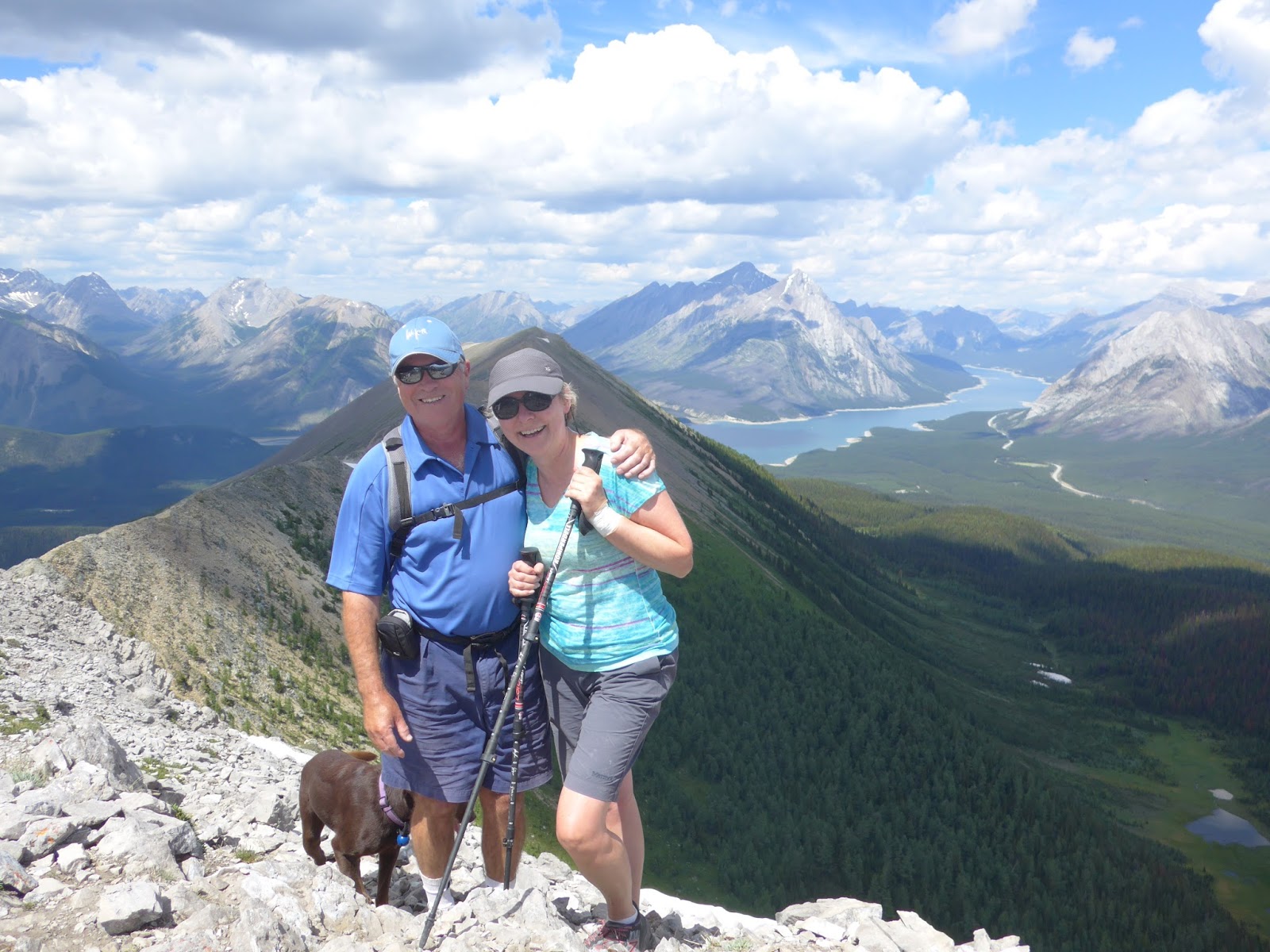
We stopped for photos at the first summit which has a weather station on top. This was probably about the 1/3rd mark of the hike for us. When you get up to this point, you can see all the way to the Robertson Glacier to the south, with lots of peaks in-between. It was really windy up there so we had our jackets on for a bit, but not for long. As soon as we started down towards the col between the two summits, we were out of the wind and nice and warm again. This was a good place to stop for lunch because it was one of the few parts of the hike that had nice soft places to sit (everywhere else was rocky), it was out of the wind, but there were no bugs.
 |
| Family photo at the first peak on the hike. |
 |
| Looking north from the first summit (from my hike the week before when it was stormy and snowing briefly) |
 |
| Lunch spot in the moss with the same mountain as above but clearer skies |
The final stretch of ascending came next. Feeling slow after a big lunch we worked our way up the scree and made it to the second summit. A whole new set of views opened up to the west (Mt. Shark, Mt. Assiniboine and Shark Lake to name a few).
 |
| Catching a breath and taking in the view at the summit cairn |
 |
| Rozzi was a happy dog on this hike! |
 |
| Angela and Mom approaching the summit (with the first peak and lunch col in the background) |
 |
| Success! |
The trail then worked its way down the west side of the horseshoe, passing some steep drop offs to the right. The trail was very rocky, with lots of big rocks to navigate so we took our time and watched our step. The ridge is wider than it looks from a distance which was good!
 |
| Rocky trail in the Rockies (actually its Kananaskis) |
 |
| A man and his dog on Tent Ridge |
The descent off of Tent Ridge was a bit steep and loose. Having hiking poles really helped. There was a bit of snow to cross and a steep descent into the valley. Everyone was happy when the trail finally leveled out in the trees. Once we reached a double track road, it was only about 1 km back to the car on easy ground (make sure to take a right at the T junction). The hike took us about 5.5 hours with a long lunch, lots of stops to take pictures, and an easy pace. I love this trail because you have views almost the whole time and there are barely any other people out there. I think we passed two groups all day.
 |
| Spray Lakes, Tent Ridge and the Kananaskis Range |


No comments:
Post a Comment