Distance: 19km
Elevation: 1700m
Time: 7.5hrs
 |
| A view of Mount MacDonald from the Connaught Slide Path on the east side of Tupper |
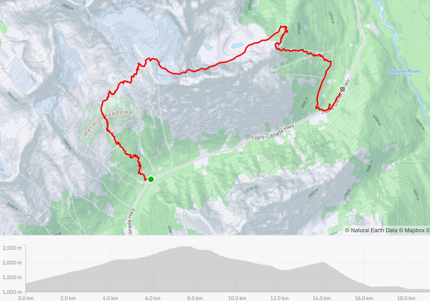 |
| The Tupper Traverse |
The Tupper Traverse is a classic Roger's Pass route that links the Hermit Parking to Stone Arch by ascending Hermit Meadows and wrapping around the back side of Tupper. It finishes with an 1100m descent down the Connaught Slide Path on the east side of Mt. Tupper and Glacier National Park. (no relation to Connaught Creek accessed from the visitor centre). We had the right combination of stoked skiers visiting from Squamish/Whistler who wanted to ski some big lines over Family Day Weekend and stable snow conditions that let us get into some bigger terrain.
 |
| Views of Mount MacDonald from the Hermit trees |
We started the day by dropping a truck off at the Stone Arch parking lot at the bottom of the Connaught Slide Path. From there, we piled into the Jetta to pick up park passes for the out-of-towners at the Visitor Centre before starting the tour from Hermit parking. It was a busy long weekend Saturday, and without any recent snow in the last 2 weeks, the Hermit skin track was a well established highway to the alpine.
 |
| Climbing through the Hermit trees and pillows in a snow globe |
It had been very cold over the preceding 2 weeks and the skin track was frustratingly icy. In true Roger's Pass fashion, it was steep. Not quite steep enough to pull out the ski crampons, but my triceps ached from using my poles to keep from sliding backwards on slippery sections.
 |
| Clouds part above us to reveal the Hermit Path and SW Face of Mt. Tupper |
We were greeted with incredible views of Mount MacDonald, Tupper and Sifton as we broke out of the trees. Sparkling snowflakes swirled around us as we climbed. It was magical.
 |
| Grizzly shoulder as seen from Hermit Meadows |
Following the obvious skin track, we broke out of the trees and into the moraines. The skin track follows the summer trail up the the campground then splits to access different zones above. We stopped for a snack and surveyed how much more we had to climb to reach the Swiss/Tupper col. The initial climb is ~1300m and feels relentless. We had to descend a few short pitches and cross a gully to continue up to the base of Mt. Tupper.
 |
| Views from the bottom of the Hermit Meadows, looking toward Swiss Glacier (right) |
Soon after we started up again, the clouds rolled in and the visibility deteriorated. Fortunately, we had a skin track to follow otherwise we would have been stuck navigating with the GPS to find the col. The most scenic part of the whole traverse was obscured by pesky clouds.
 |
| The clouds roll in as we start climbing to the Swiss/Tupper col |
We reached the col without any improvement in the weather. It was windy and cold on the ridge so we transitioned quickly and started to ski down. Fortunately the descent down the Tupper Glacier is fairly straight-forward and Kyle had vague memories of it from when he did the traverse 7 years ago.
 |
| Transitioning at the top of the Tupper Glacier, no views to be seen |
We kept the looming presence of Mt. Tupper on our right as we descended. Even though we couldn't see it at times, we could feel it towering over us. Dropping down the glacier, the cloud thinned and we finally had some visibility. The skiing was challenging wind crust and not the most enjoyable.
 |
| Skiing down the Tupper Glacier into better visibility |
Emerging from the clouds, we finally could see the huge north face of Mt. Tupper above us and the Tupper Creek below. We didn't get the epic views of Mt Rogers, Swiss Peak and Hermit that we had been hoping for, but the views east down towards Beaver Valley were beautiful and a different vista than what I am used to in Roger's Pass.
 |
| Looking back to Mt. Tupper (left) and Mt. Hermit (right) |
We descended to 1750m and into the trees where we finally got some reprieve from the wind. After fueling up on hot tea and a big lunch, it was time for the second climb of the day, ~400m up and around the eastern rib of Mt. Tupper to access the Connaught Slide Path.
 |
| Puff daddys |
 |
| Climbing out of Tupper Creek to reach the shoulder of Tupper |
The coolest part about the Tupper Traverse is that you wrap around the impressive mountain and get to see it from a bunch of different angles. While we didn't get the classic view of the western rib and summit, we still got to see it from a unique vantage point and explore a new (to me) part of Roger's Pass.
 |
| View back at Mt Tupper from the top of Connaught Slide Path (Vince Shuley Photo) |
After the subpar skiing on the Tupper Glacier, the Connaught Path was a treat. There were pockets of fresh snow that was skiing really well, and lots of little pillows to jump off on the way down. 1100m of descending goes by quickly on a big open run!
 |
| Ready for the long run down |
The final challenge of the day was getting back to the car. Because the parking lot is on the other side of the railway track, you can't ski directly to the vehicle despite it being about 100m away from the bottom of the slide path. You need to exit the slide path on skiers right and skin along an old railbed for about 2km. Orange diamonds mark the designated access route to cross the tracks but they can be easy to miss! We found the crossing where the tracks dip into a train tunnel, then followed the sidehill skin track back to the Stone Arch parking lot. We did get to cross the stone arch bridge on the way. Now I know where the parking lot got its name!
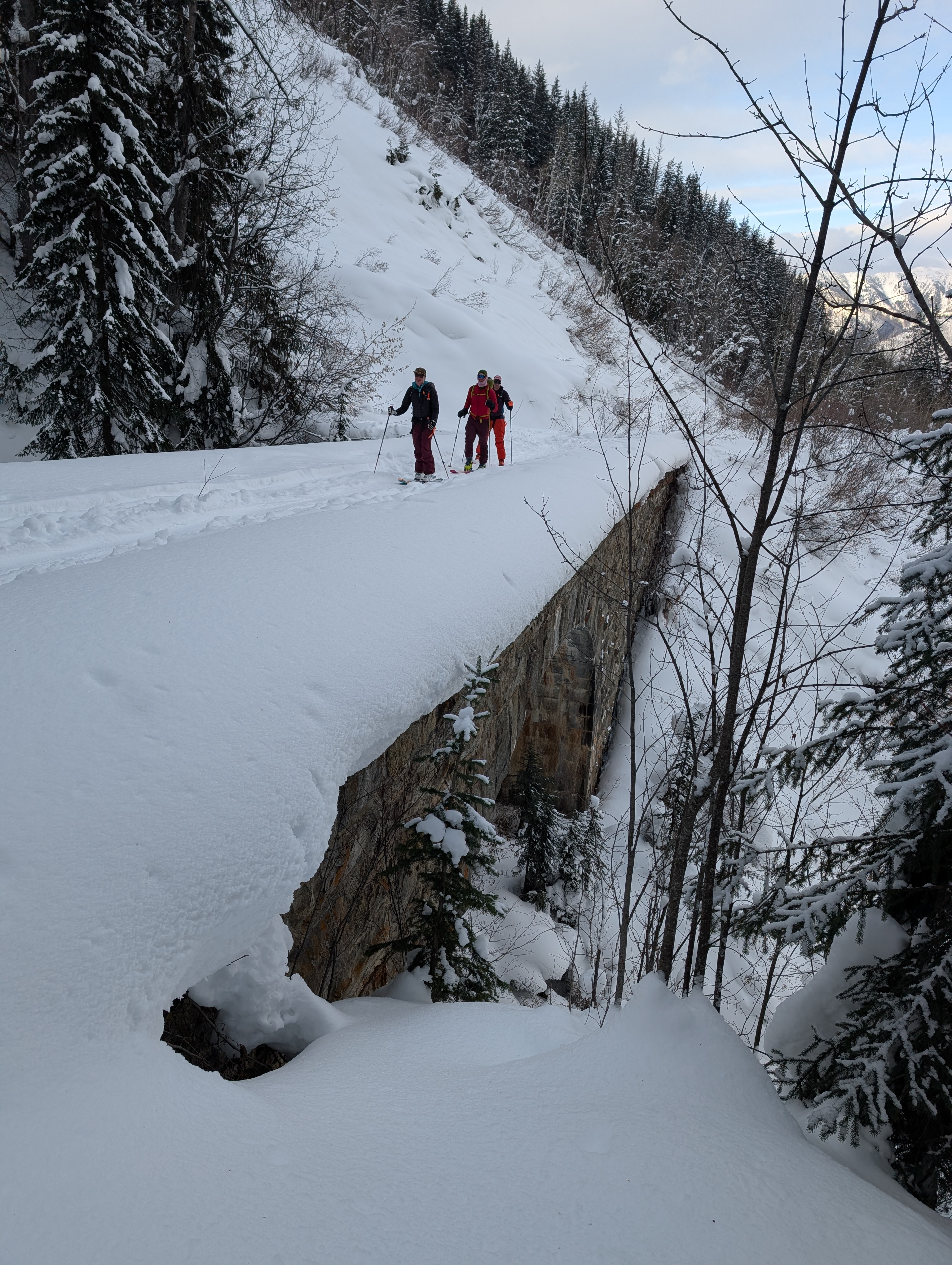 |
| Crossing the Stone Arch on the Tupper designated access route to cross the train tracks |
No comments:
Post a Comment