Peter, Kristina, Kyle and I hiked Northover Ridge as a 3 day backpacking trip this past weekend. We completed the 33km loop in the counter-clockwise direction, camping at Three Isle Lake and Aster Lake. It was a beautiful fall weekend in the Rockies, complete with yellow larches, blue skies and a skiff of snow on the peaks. We were pretty lucky to be able to do this trail so late in the season and were rewarded with endless mountain views, surprising warm weather and very few people on the trail. As a result, we took LOTS of pictures.
 |
Sunset over Upper Kananaskis Lake on Thursday night
|
We left Calgary after work on Thursday to meet at the North Interlakes parking lot in Peter Lougheed Provincial Park just before 7pm. We hustled to get on the trail and hike as much as we could before dark. The first 7km to the Forks Campground was easy going and quite flat and we covered ground quickly, stopping briefly to pull out headlamps to light our way. The Forks Campground is currently closed due to some downed trees. We had originally considered camping there on Thursday night so we would have a shorter evening hike, but I had received a call from parks earlier in the day that informed me the campground was going to be closed for an unknown amount of time. It made the decision to carry on up to Three Isle Lake pretty easy and also made our second day much nicer (we would have had to do all our elevation on day 2 if we stayed at the Forks).
 |
| Up the headwall to Three Isle Campground |
After the Forks the trail starts climbing, gaining 500m over 4km to reach the campground. We did this part in the dark with an almost full moon lighting the way. We arrived at the campsite at 10pm after 3 hours of hiking. The campground has lots of tent pads, an outhouse, bear lockers and picnic tables. After setting up tents we made some hot drinks before bed. The temperature had dropped after the sun went down and it was a cold night. Fortunately we had packed accordingly with lots of warm layers!
We awoke to sunny skies and frost. With only 11km to cover that day to Aster Lake, we had a lazy morning in camp, finally departing at the crack of 11.
 |
| Morning foundations before our ridge day |
 |
Three Isle Lake
|
The trail follows the lakeshore heading left from the campground. We passed a ranger cabin before turning up a wide valley. The trail wasn't very obvious and we walked up a creek bed until we found some cairns that marked the way on the west side (lookers right) and regained the trail.
 |
Mt. Worthington rises about Three Isle Lake as we hit the trail
|
 |
A bit of snow ahead as we get our first glimpse of the pass and ridge
|
Looking down the valley, we had views of Northover Glacier and Northover Ridge. As we approached, the ridge dominated the skyline. The trail climbs up a scree slope to a low saddle, then gains the ridge to the left. Some snow was visible in the alpine but it didn't look like it was going to be an issue.
 |
| Heading up the creek bed towards Northover Glacier |
When we finally started gaining elevation, there was no messing around. The trail turned straight up the hill and was unrelenting. We passed through a band of larch trees that filtered the sunlight in a surreal yellow glow before popping out into the rocky alpine.
 |
Gaining elevation now through the larch forest
|
 |
Looking back down at Three Isle Lake as we leave the larches behind
|
 |
Up into the alpine
|
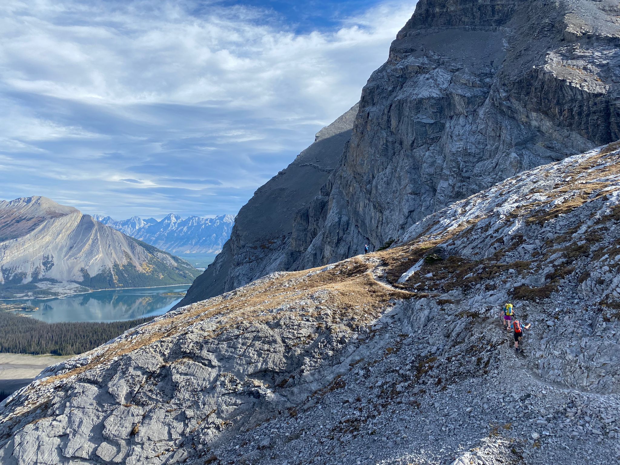
We followed switchbacks up the scree to gain the saddle below Northover Ridge. From here, the rest of our elevation would be gained by climbing the narrow ridge.
 |
| Straight up the scree to the gain the ridge |
 |
Made it to the pass, now time to climb the ridge!
|
Soon, we were at the high point of the ridge and we could see our route stretching out ahead. The ridge walk of this route is 3km long and has amazing views of the Royal Group, Warrior Mountain, Joffre and beyond. This is definitely the highlight of the route. The trail was in good shape with minimal snow. It was narrow in sections with steep slopes dropping down to the valley on both sides but overall felt very secure. There was one very narrow section (~10m long) that got the adrenaline going, and we took our time crossing slowly with our heavy overnight bags.
 |
| High above Three Isle Lake |
 |
| Peter and Kristina with views of Mt. King George |
 |
Long ridge ahead!
|
 |
| Made it through the narrow, exposed crux of the ridge-walk |
 |
Beautiful day for a hike
|
The ridge got wider as we continued over undulating terrain. Warm, gentle winds blew up from western slopes on the BC side of the ridge. We descended a steep scree slope beside the peak of Mt. Northover down towards the Northover Tarns. You can random camp here as it is not in the Peter Lougheed Park (it is actually in British Columbia!). An obvious trail lead us down between Mt. Northover and Warrior Mountain through the scree.
 |
| Northover Tarns below Warrior Mountain with Glaciated Mt. Joffre in the background |
 |
Descending the flank of Mt. Northover to Aster Lake
|
After rounding the corner of Mt. Northover, we were able to see Aster Lake, our destination for the evening. We were still high above the lake and had to descend a rocky slope to the valley bottom. The trail had disappeared and we intermittently followed animal trails, noting that grizzlies had been very active in the area with lots of dug up ground. When I was researching the route, this is where people seem to get lost when approaching from the Aster Lake side, since the trail is very faint. If you aim for Warrior Mountain, then turn right up the large valley between Northover and Warrior you will find the route!
 |
| Lost the trail |
The main hiking trail takes you around Aster Lake on the south shore (beside Mt. Marlborough) but it looked way less direct. We decided to follow the north shore which meant multiple creek crossings and no trail to follow. It was slow going and we were eager to get to camp. It may have been faster to just follow the trail.
 |
Aster Lake - so close yet so far
|
 |
| Fall colours in the alpine |
 |
One of many creek crossings
|
 |
| Looking for the best place to cross |
We arrived at camp after about 6 hours of hiking. Although it was only 11km and ~900m of elevation gain and loss from Three Isle to Aster, the hike had taken most of the day. The campground was bathed in sunlight and we set up our tents and dipped our aching feet in the creek. The campground has 6 tent pads, as well as bear bins and an outhouse with amazing alpine vistas. We were in bed very early that night.
 |
| Good morning from Aster Lake Campground! |
We enjoyed another lazy morning at camp before the final 11 km hike back to the car. From Aster Lake, you hike down the summer trail beside Fossil Falls and past Hidden Lake (which was totally dry this time of year) to the Upper Kananaskis Lake Trail. It was basically all downhill. Just below camp, there were tons of fossils of sea creatures in the rocks. It was very cool. We meandered up and down through the forest to the point where we pulled out the map to confirm we were on the correct trail. There is a side hike up to Marlborough pond, but we never saw a junction for it. Shortly after checking the map, we passed a sign for a ranger cabin and confirmed that we were going the right way, and passed a big group of trail runners coming up the trail who were doing the loop in a day.
 |
| And the "best view form an outhouse" award goes to... |
 |
| Heading down beside Fossil Falls just below camp |
 |
Fossils everywhere
|
As the trail descends beside Mt. Sarrail to the right of Fossil Falls, it gets a bit tricky. There were some loose, exposed sections over a rock band where a fall could be pretty serious. This was followed by a steep scree sidehill descent. Some of the hikers coming up the trail seemed pretty nervous about the exposure and I was happy to have my hiking poles!


No comments:
Post a Comment