Cape Town South Africa is probably one of the most beautiful cities in world thanks to its stunning ocean, beaches and mountains. Kyle and I had the opportunity to explore the area close to town by ticking off some of the top hiking trails, most of which were different ways up the predominant feature in the city, Table Mountain. I have included a small write up and photos for each of the hikes that we did:
1. Kasteelsport (Table Mountain)
2. Skeleton Gorge (Table Mountain)
3. India Venesters (Table Mountain)
4. Lions Head (Signal Hill)
5. Disa Hike (Hout Bay)
 |
| The view of Cape Town from the top of Table Mountain (near the cable car station) |
A bit of info about Table Mountain: There are many different ways up Table Mountain and each has its own charm. They are steep and direct so get ready to sweat! Most of the trails up Table Mountain are not as fun to walk back down. Since Table Mountain is a large plateau, the hiking trails only take you up to the plateau's edge. After that, a network of trails criss-cross the mountain-top and are worth checking out after all the hard work of getting up there. Many people take the cable car back to the bottom of the mountain (190 R for a one way ticket, about $20 CAD Cable Car Prices). An alternate way down would be down the Platteklip Gorge trail, the easiest descent trail that ends about 1 km from the gondola station. There are small maps at major intersections on top of the plateau, but overall it was a bit challenging to find a good map of the whole area.
 |
| Map showing Platteklip Gorge trail and the Cable Car |
Getting There: We found Uber to be the most efficient way to get to the trailheads, and around Cape Town in general! It was cheap, pickups were almost always within 10 mins, and it meant that you could hike up one way and descend another way without worrying about where you parked. We never had an issue with a driver finding a trailhead and always felt very safe with our Uber drivers.
Safety: There have been muggings and assaults on Table Mountain. We spoke with a number of locals who warned us about hiking alone. They noted that most attacks occurred when people were not paying attention to their surroundings, for example stopping to take photos on expensive phones and looking up to see guys surrounding them. We decided to carry mace with us whenever we went hiking and made an effort to be vigilant. We had no negative encounters and felt overall very comfortable hiking as 2 people.
Weather: The weather on Table Mountain is notorious! Although it is easily accessible from the city, it is still a mountain and the clouds can move in quickly. It can be many degrees colder than at the base, or windy and rainy when it is sunny in town. Bring layers and be prepared for weather, even if you just take the cable car up the mountain. High winds can close the cable car mid-day, forcing unsuspecting, flip-flop wearing tourists to hike down. Also, if it isn't windy, it can be very hot. Bring lots of water. There are fountains at the top of the gondola, and streams on the plateau but be prepared so you don't run out
 |
| Table Mountain covered in clouds ("the Table Cloth), a common sight |
1. Kasteelspoort Trail (Table Mountain)
Trailhead:
Start at the top of Theresa Ave in Camps Bay (western side of Table Mountain in the 12 apostles), follow the Jeep Track up until you reach the sign for Kasteelspoort Trail. You can also start on the Pipe Track Trail which adds a bit of distance
Distance:
About 3 km to the old cable car station on the plateau
Approximate time:
It took us about 1 hour of steady hiking to reach the view point at the top of the trail. We were moving quick and passing lots of groups
Shade:
Morning shade, afternoon sun
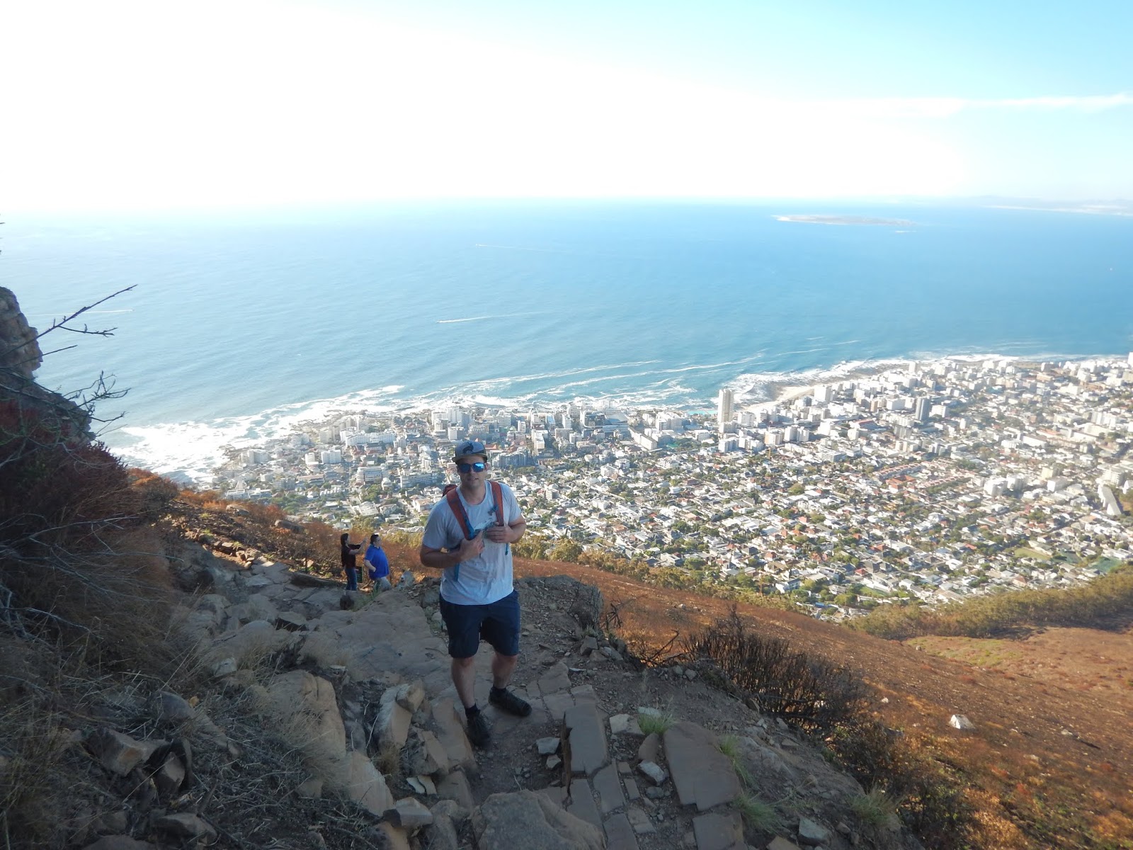
The Kasteelspoort hike was excellent. It wasn't too technical and only had a few small sections of scrambling with minimal exposure (compared to other routes on Table Mountain). It was shady in the morning which helped us stay cool. There are nice big flat areas to stop and rest along the way. Once we reached the top, there was an amazing view back to Camps Bay and out over the Atlantic Ocean.
We continued hiking once we reached the top and went to explore the reservoir and some of the lesser marked trails that wound through valleys and gorges (Echo Valley) to take us back to the Cable Car station. It took us about 3-4 hours more hiking to reach the cable car. We opted to descend via the Platteklip Gorge trail which took about 1 hour to descend.
 |
| Sign to Kasteelspoort with views of Camps Bay below |
 |
| Amazing views from the top of Kasteelspoort |
 |
| The prominent rock featured in many instagram feeds! |
 |
| Table Mountain plateau with views south towards Cape Peninsula (Cape of Good Hope) |
 |
| Exploring the gorges on the plateau with Em and Trev! |
 |
| Kyle discovers a boulder problem |
2. Skeleton Gorge to Maclears Beacon
Trailhead:
Start at the Kirstenbosch Botanical Gardens. You need to pay an entry fee to get into the gardens (R70 for adults - $7 CAD). The gardens do not open until 8 am. Accessing the hiking trail is easiest from Gate 3 (the upper gate is at Rhodes Drive and Klaasen's Road). Once in the park, follow signs for Skeleton Gorge.
(Apparently you can avoid going through the park by starting from Cecilia Forest on Rhodes Drive which only adds 10 mins - Hiking Chronicles Website)
Distance
7 km
1000m elevation
Approximate Time:
4 hours from the Botanical Gardens to the Cableway Station
The Skeleton Gorge trail follows a deep ravine up the east side of Table Mountain. The trail takes you past some small waterfalls and up wooden ladders, followed by a bit of a scramble up a dried river bed. It is pretty steep and gains 700m fairly quickly. Once at the top, follow Smut's Track to Maclears Beacon (300m of elevation). From there, it is almost all downhill to the cableway station!
 |
| Views of Maclears Beacon, the highest point on Table Mountain from Kirstenbosch Botanical Garden |
 |
| Making our way through Kirstenbosch to Skeleton Gorge (large valley on the right) |
 |
| Stairs and forest canopy |
 |
| Follow the signs for Skeleton Gorge |
 |
| Wooden stairs/ladders |
 |
| Maclears Beacon |
 |
| Following the trail from Maclears Beacon to the cableway station |
 |
| Dense fog rolls in |
 |
| Dassie (aka Rock Hyrax) are found at the top of Table Mountain and are the closest living relative to the elephant! They will also try to steal your lunch! |
3. India Venster
Trailhead:
Start about 50 metres to the right of the Table Mountain Cableway station. Take the rocky trail straight up to the contour path and follow signs for India Venster Trail. Yellow footprints painted on the rock mark the route
Distance:
2.5 km
670m of elevation
Approximate Time:
1.5 hours
The India Venster Trail has a reputation for being scary. There is significant exposure and a few pitches of via ferrata style scrambling that isn't the most intuitive. If you don't like heights, maybe give this one a miss. The trail works its way up under the cable car then traverses under the steep rock face along Fountain Ledge. From the ledge, you have amazing views of Camps Bay and the 12 apostles of Table Mountain. The hike finishes at the Cableway Station, making for an easy descent.
 |
| Looking up the most direct trail to the top! |
 |
| Warnings to tourists |
 |
| Gaining elevation quickly |
 |
| View of the Lions Head, cable car and the trail that we just came up |
 |
| Follow the yellow foot prints! The scrambling begins |
 |
| Via ferrata rungs and chains for the steep sections |
 |
| Happy Jenny |
 |
| Rounding the corner onto Fountain Ledge |
 |
| Views of Camps Bay and the 12 Apostles |
4. Lions Head
Trailhead:
Start at the Lions Head parking lot on Signal Hill Road. Follow signs for the Spiral Trail
Distance:
5 km round trip
450 m elevation
Approximate Time
45 min up
The Lion's Head is a very popular sunrise and sunset destination. We were fortunate to be able to hike this trail right at the end of our trip. The trail had been closed for maintenance, and right before it was supposed to re-open, a wildfire on Signal Hill/Lions Head caused delays to the opening. We managed to hike it a few days before leaving, on opening day! We went up for sunset and brought a massive picnic. I would recommend giving yourself plenty of time to enjoy the top before the sun goes down so that you can still hike out in the daylight. It was busy up top, but the views were worth it! The hike follows a road and winds its way in a loop around the mountain. Near the top, it is more of a scramble with a direct and easier way. The final climb to the top is steep but not too exposed. Be careful of the other hikers, the trail gets pretty congested.
 |
| Wrapping around the back side of Lions Head |
 |
| Kyle unpacks our picnic, overlooking Sea Point and the Atlantic |
 |
| Yoga poses over Cape Town |
 |
| Shadows on Table Mountain and Devils Peak |
 |
| Looking down the coast to the 12 Apostles |
5. Disa Hike - Hout Bay
This wasn't an official trail, but we got invited to go check out the Disa's with some friends of friends. Disa's are Cape Town's official flower and they only bloom at very specific times of the year. They are not very common and can be tricky to find. We were lucky to be in town at just the right time and got to see them on our hike in Hout Bay. We also saw them up on Table Mountain next to some of the streams. If you happen to be in Cape Town in February, look out for these delicate pink orchids!
 |
| We found the Disas |
 |
| New friends |
 |
| Disa |
 |
| Steep track to get to the flowers |
No comments:
Post a Comment